Signed in as:
filler@godaddy.com
Drone power line inspection software with data management, collaboration and AI enablement in one platform. aerial utility inspection software will improve organizational productivity, accuracy and capacity through automation and workflow standardization – upload, analyze, prioritize and take action on drone powerline inspection program data in a single platform.
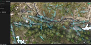
The Biodrone Portal is an end-to-end platform for efficient and accurate processing of aerial gathered image data by using artificial intelligence. Count and categorize objects, calculate values, detect damages and identify risks to make insight-driven decisions.

AI enhanced oil and gas inspections; Automatically detect, track and label plant equipment and infrastructure. Use AI to determine where to focus inspection efforts. Aerialtronics is an end-to-end solution developer that utilises drones, artificial intelligence and IoT data to provide businesses with augmented and actionable insights that create a perfect synergy between aerial applications and everyday business operations.

Enchance your drones with AI and Computer Vision technology that is tailored to your drone use case.
Streamline your inventory tracking, enhance safety checks, and get real-time insights that make a difference. Incorporate RFID-equipped drones in large industrial spaces to track assets more effectively. These drones scan RFID-tagged equipment, so industry workers can quickly locate items, improve their use, and schedule maintenance easily. Implement cutting-edge preventive maintenance strategies with sound-sensing drones. These drones have sound sensors for object detection, and they can distinguish between the normal operational sounds of machinery and any irregular noises indicating potential failures. Detect issues early, prevent costly downtime and boost maintenance operations. ntelligent agricultural drones, equipped with advanced vision systems, offer a groundbreaking approach to identifying fence breaches, safeguarding your livestock from potential escape, and utilising drone AI technology for seamless farm management tasks.

FlytBase is a hardware-agnostic, enterprise-grade software platform that is designed to enable fully autonomous and Beyond Visual Line of Sight (BVLOS) drone operations. Built with data security at its core, FlytBase is ideal for businesses looking to manage drone dock operations with safety, reliability, and efficiency. This platform supports a wide range of drone hardware, making it a flexible choice for various industries that require automated drone operations.
FlytBase focuses on providing a comprehensive solution for docked drone operations, allowing users to manage one-to-many drone operations, integrate joysticks, and share live mission data securely. With a strong emphasis on enterprise needs, the platform offers features like remote operations management, team coordination, and robust data storage options. FlytBase is designed to scale with the needs of businesses, from those just starting with docked drone operations to large enterprises requiring extensive integrations and automation.
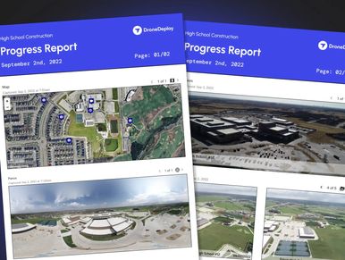
DroneDeploy is a powerful software platform designed to optimize and streamline drone operations across various industries. It offers a cloud-based solution that allows users to plan, capture, and analyze aerial data efficiently. With its wide range of features, DroneDeploy caters to industries such as construction, agriculture, real estate, and environmental monitoring, providing tools that enable detailed mapping, 3D modeling, and real-time data processing.
One of DroneDeploy’s key strengths is its user-friendly interface, which makes it accessible even to those without extensive technical expertise. The platform supports a variety of drone hardware, ensuring flexibility and adaptability in different operational environments. By leveraging advanced analytics and AI, DroneDeploy helps businesses make informed decisions based on accurate aerial data, enhancing productivity and reducing operational costs.
PX4 is an open source flight control software for drones and other unmanned vehicles. The project provides a flexible set of tools for drone developers to share technologies to create tailored solutions for drone applications. PX4 is hosted by Dronecode, a Linux Foundation non-profit. PX4 is used in a wide range of use-cases, from consumer drones to industrial applications. It is also the leading research platform for drones and has been successfully applied to under water vehicles and boats. PX4 provides a standard to deliver drone hardware support and software stack, allowing an ecosystem to build and maintain hardware and software in a scalable way. Drone development is complicated, and how to get started can be daunting and hard to navigate. These tutorials and resources provide a walkthrough of the basics of PX4.
Flight Optimization and Automation Platform for Commercial Drones.
Smart Flight™ uses AI-powered autonomy to increase the capabilities of any drone and to remove the dependency on experienced pilots. It allows one operator to command many drones by simply setting their goals. Smart flight will then dynamically determine optimal actions, coordinating drones and guiding them along routes that harness wind power, while avoiding no-fly zones, obstacles and bad weather. This enables drones to fly 8 times longer and 30% faster, unlocking endless new opportunities and enabling safer, scalable operations.
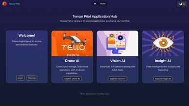
Tensor Pilot is a versatile AI drone software designed to enhance drone operations by integrating advanced AI capabilities. The software comes in two versions: Tensor Pilot Basic and Tensor Pilot AI, catering to users with different operational needs. Tensor Pilot AI offers advanced features such as object detection, human pose detection, and face mesh, which allow for more refined and precise drone missions. In contrast, Tensor Pilot Basic provides the essential functionalities needed to operate drones but lacks the AI-driven tools present in the AI version. Integrate our software into your educational programs to provide students with hands-on learning experiences in robotics and drone technology.
it’s a full operational management suite for commercial drone businesses. While not a photogrammetry engine itself, it excels at integrating mapping tools into a robust system for planning, compliance, and client delivery. In 2025, DroneDesk shines as the ideal software for drone operators who need both strong administrative control and seamless mapping workflows.
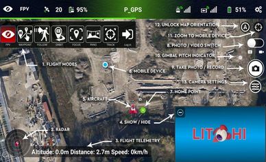
If you want more control over camera angles, waypoints, and gimbal behavior, Litchi is a top pick. Popular with DJI pilots, it allows for detailed flight route programming and camera control via desktop and mobile.
Key Features:
VR mode and FPV support
Waypoint missions with customizable speed, altitude, and POI focus
Offline planning with Google Earth integration
Cross-device mission syncing.
Designed for complex and large-scale missions, UgCS provides professional mission planning tools with support for multiple drone types, including fixed-wing and multirotor platforms. It’s especially useful for industrial inspections, LiDAR surveys, and search and rescue.
Key Features:
Terrain-following flight paths for mountainous regions
Live telemetry and pilot handoff features
Custom flight planning for corridor mapping and vertical scans
Supports multiple manufacturers including DJI, Yuneec, and custom drones

ArcGIS Drone2Map is a robust desktop application designed to meet the needs of GIS professionals and drone operators who require precise mapping and analysis from drone imagery. Fully integrated with the ArcGIS system, Drone2Map allows users to process drone-captured images and publish results seamlessly within the ArcGIS ecosystem, either through ArcGIS Online or ArcGIS Enterprise. The software is particularly beneficial for creating accurate orthomosaics, digital surface models (DSMs), digital terrain models (DTMs), and 3D models, catering to a wide range of industries including agriculture, construction, and environmental management.
Drone2Map is available in two versions: Standard and Advanced, each offering a different set of tools tailored to specific user needs. The Standard version provides essential tools for generating 2D image products and performing basic analyses directly within the app. The Advanced version builds on these features, adding 3D modeling capabilities and more sophisticated processing options to deliver realistic and detailed representations of terrain and structures. Both versions support a range of languages, making the software accessible to a global user base.
The Eagle Map by JOUAV is an advanced aerial mapping system specifically designed for high-precision mapping and surveying applications. This UAV (Unmanned Aerial Vehicle) system is equipped with cutting-edge technology to capture detailed aerial imagery and generate accurate geospatial data. The Eagle Map is tailored for industries such as construction, agriculture, environmental monitoring, and urban planning, where precise data is crucial for decision-making.
One of the key features of the Eagle Map is its integration with high-resolution cameras and sensors, enabling it to perform complex mapping tasks with high accuracy. The system is designed to be user-friendly, allowing operators to plan and execute mapping missions efficiently. With the Eagle Map, users can generate orthomosaics, digital elevation models (DEMs), and 3D maps that provide detailed insights into the terrain and structures being surveyed. The system is also equipped with automated data processing capabilities, reducing the time and effort required to analyze the captured data.
DJI FlightHub 2 is a cloud-based drone management platform designed to streamline and enhance drone operations for various industries. It supports complex missions by providing a centralized interface for managing drone fleets, monitoring live operations, and analyzing data. The platform is particularly beneficial for sectors like public safety, construction, infrastructure inspection, and agriculture, where efficient coordination of multiple drone operations is critical.
FlightHub 2 offers a range of features to facilitate drone operations, including real-time mapping, annotation and sync maps, and the ability to share device locations. It integrates seamlessly with DJI drones, ensuring that users can easily manage and control their drone fleets. The platform is available in two versions—Standard and Professional—each offering different levels of functionality to meet the needs of various users.

The Autel SkyCommand Center is a comprehensive drone management platform developed by Autel Robotics to provide advanced control, monitoring, and analysis capabilities for drone operations. This platform is designed to enhance the efficiency and safety of drone missions by offering real-time data visualization, fleet management, and automated mission planning. The SkyCommand Center is particularly useful for industries such as public safety, energy, infrastructure inspection, and agriculture, where precise and coordinated drone operations are crucial.
SkyCommand Center allows operators to manage multiple drones simultaneously, providing a centralized interface for mission planning, flight control, and data analysis. The platform supports real-time video feeds, flight telemetry, and map overlays, enabling operators to monitor drone activities in real-time and make informed decisions quickly. Additionally, it offers secure data storage and transfer, ensuring that all mission data is protected and easily accessible for post-flight analysis.

Skydio Cloud is an advanced drone management platform developed by Skydio to enhance the capabilities of drone operations through centralized control, real-time data management, and AI-driven analytics. This platform is designed to streamline the entire workflow of drone missions, from planning to execution and post-flight analysis, making it an ideal solution for industries like public safety, infrastructure inspection, and asset management.
Skydio Cloud integrates seamlessly with Skydio’s autonomous drones, allowing operators to manage fleets, monitor live operations, and access detailed flight data from anywhere with internet access. The platform offers powerful tools for mission planning, automated data processing, and secure storage, ensuring that all mission data is easily accessible and protected. One of the key features of Skydio Cloud is its ability to leverage AI to automate complex tasks, such as anomaly detection and asset inspection, reducing the need for manual intervention and improving overall operational efficiency.
Pix4Dmapper is a powerful photogrammetry software designed to convert aerial images captured by drones into precise 2D maps and 3D models. This software is widely used in industries like construction, surveying, agriculture, and mining, providing professionals with the tools necessary for high-precision mapping and data analysis.
Pix4Dmapper supports a range of devices, including drones, planes, and handheld cameras, making it a versatile solution for generating accurate geospatial data. The software allows users to create point clouds, digital surface and terrain models, and orthomosaics, all while integrating smoothly with other GIS and CAD tools for further data analysis.
Propeller is a cloud-based platform designed for managing and analyzing data captured by drones, specifically tailored for industries such as construction, mining, and earthworks. The platform converts drone imagery into accurate 3D maps, models, and reports, providing users with the tools they need to measure, manage, and visualize their work sites. Propeller’s technology is known for its precision, making it an essential tool for professionals who rely on accurate site data for project planning, tracking, and decision-making.
Propeller’s platform integrates seamlessly with drone hardware and ground control points (AeroPoints), ensuring that every survey delivers high-precision results. The platform’s user-friendly interface allows teams to easily upload, process, and analyze data, facilitating better collaboration and more informed decision-making. Whether it’s tracking progress, calculating volumes, or ensuring compliance, Propeller provides the detailed insights needed to manage large-scale projects efficiently.
QBase 3D is an all-in-one mission planning, flight monitoring, and data post-processing software developed by Quantum Systems. It is specifically designed to optimize the performance of Quantum Systems’ UAVs, particularly those in the Trinity™ Pro series. QBase 3D stands out as a user-friendly and intuitive solution that requires no prior training, making it accessible to both novice and experienced drone operators. The software is engineered to efficiently generate precise and safe flight paths, saving operators valuable time and ensuring the reliability of data collected for post-mission analysis.
QBase 3D is the most convenient software solution for planning and executing surveying tasks with Quantum Systems UAVs. It offers a range of benefits, including integrated imagery and Digital Terrain Modeling (curated from ESRI data), 3D mission viewing and planning, and live monitoring of mission progress and aircraft status. The software also features automated data post-processing, ensuring that operators can quickly and accurately analyze the data collected during missions.

Avision is an advanced drone management platform designed to enhance the safety, efficiency, and effectiveness of drone operations. The platform offers a fully integrated solution that caters to various drone use cases, including last-mile logistics, commercial operations, and recreational flying. Avision’s software suite provides essential tools for mission planning, real-time operational visibility, and compliance with airspace regulations, making it a valuable resource for both hobbyists and professional pilots.
One of the key features of Avision is its integration with UTM (Unmanned Traffic Management) systems, which enhances operational safety and situational awareness. The platform supports a wide range of functionalities, from basic recreational use to advanced enterprise-level operations. Avision is accessible through web, iOS, and Android applications, ensuring that users can manage their drone flights from any device, anywhere.
Maps Made Easy is a powerful platform designed for creating high-resolution aerial maps using drone-captured images. The platform is tailored for both hobbyists and professionals, offering a range of tools and features that enable users to produce detailed 2D maps and 3D models. Maps Made Easy is known for its ease of use, making it accessible to users with varying levels of experience in drone mapping and photogrammetry.
Maps Made Easy supports a variety of mapping needs, from basic map creation to more advanced terrain and thermal processing. Users can upload their drone images to the platform, which then processes the data to create high-quality orthomosaics, digital elevation models, and other geospatial outputs. The platform also integrates with Map Pilot Pro, a companion app that aids in mission planning and data collection, further enhancing the mapping experience.

AI software that works with virtually any hardware. Software-first solution powers drones with AI so you can count inventory 25x faster with 99.9% accuracy while cutting costs. They’re compatible with any warehouse environment, including narrow aisles, dark lighting, and down to -20°F. No infrastructure changes needed.

FlyPix AI, specializes in geospatial technology, transforming complex aerial images into actionable, geo-referenced insights using advanced AI. The platform supports operations in sectors like government, construction, and agriculture by offering precise solutions for object detection, tracking, and monitoring. Powered by deep learning algorithms, system delivers detailed analysis and dynamic tracking, enabling clients to make informed decisions based on the most accurate geospatial data available.
Technology provides users with tools for comprehensive object analysis, essential for environmental monitoring, urban planning, and infrastructure management. The adaptability of the AI models allows for customization to meet industry-specific needs, offering flexibility in application. One of the standout features of our platform is its intuitive interface, which simplifies the visualization and reporting of geospatial data, making it accessible to both technical experts and decision-makers alike. This user-friendly design, combined with efficient data processing, results in significant cost savings and a competitive advantage for our clients.
FlyPix AI, prioritizes security and integration capabilities, ensuring that data integrity and security are always upheld. System seamlessly integrates with existing GIS platforms, enhancing its functionality without interrupting established workflows.

Dynamic Cognitive Mesh for Drone Communication
Dynamic network enabling cognitive mesh communication of large heterogeneous swarms of drones & ground robots. Fly4Future has successfully created a sophisticated multi-modal network that not only ensures seamless connectivity, but also enables ad-hoc communications (RF and optical) within extensive heterogeneous swarms. These swarms are comprised of a wide variety of autonomous drones (UAVs) & unmanned ground robots (UGVs), The network is highly dynamic, allowing for the seamless forwarding of information between drones, regardless of their location within the swarm. This means that data, video, photos, and even control commands can be effortlessly transferred between different drones, facilitating efficient data sharing and coordination. The dynamic cognitive mesh relies on both optical and RF technology, providing medium and long range communication channels that can be combined for a variety of applications.

Meshmerize is a game-changer in drone networking technology, offering resilient, dynamic, and nomad networking capabilities. With Meshmerize, drones can form an independent wireless network without relying on cellular coverage, but smartly utilizing it wherever it is available.
the true potential of UAVs hinges on the power of reliable, efficient last mile connectivity – a critical element that Meshmerize brings to the forefront. Every UAV Becomes an Access Point: Drones relay messages among themselves and to the gateway node.
Reliable and Resilient Connectivity: Drones build low-latency connectivity resilient to mobility and environmental changes.
Hardware independence: Meshmerize coexists with the existing infrastructure, adding value rather than replacing it. Being a hardware-independent product, Meshmerize can be installed directly on drones, making it a cost-effective solution. Drones can act as Access Points, building a dynamic network when and where required, expanding coverage to remote areas.
Drone Swarms: Our software scales over 200 nodes, enabling distributed control and low-latency connectivity.
Perfect last-mile : In a way, Meshmerize provides the perfect last mile connectivity for patchy cellular networks.

is a technology company specializing in AI drone, Drone as a Service (DaaS), enterprise SaaS and Quantum Computing solutions for mission-critical business applications. Introducing the ZenaDrone 1000, an advanced unmanned aerial vehicle (UAV) with heavy-lift capabilities, stable flight characteristics, and exceptional maneuverability. With extended flight time and impressive long-range capabilities, this cutting-edge drone is perfectly suited for military operations, industrial tasks, agricultural surveys, and humanitarian missions, offering a diverse range of applications to meet industry-specific requirements.

We develop innovative solutions and products in the fields of Unmanned Systems, Smart Health, Smart Cities, Artificial Intelligence and Big Data for both the National and International markets and also developing solutions and products in different technological areas. With the decentralized (distributed) control architecture we have developed with Artificial Intelligence, Deep learning and Image Processing technologies, we are developing portable unmanned platforms that can perform tasks in swarms even in areas where there is no data communication.
Increase safety, efficiency and sustainability with the operating system for autonomous robots. Skynode X is the fastest way to power drones with the Auterion software platform. An all-in-one integrated autopilot and mission computer to enable autonomous flights, mission planning, live video streams, an operations dashboard, flight analytics and cloud-based predictive maintenance.
MSTC, we lead the way in advancing technological solutions for critical infrastructure monitoring. Our AI Drone Solutions redefine pipeline monitoring, leveraging the power of Artificial Intelligence, thermal imaging, and state-of-the-art leak detection technology. Explore the possibilities of enhanced efficiency, reduced downtime, and proactive maintenance with our specialized services.
AI Drone Inspection Software to Automate Your Operations
From aerial mapping and modeling to precision agriculture and beyond, our platform empowers your drones to provide real-time data and analytics, revolutionizing the way you do business

Skylark Drones is a technology company that is building the core infrastructure for the global drone ecosystem. Today, our platform empowers Fortune 500 companies with drone analytics, service providers with secure execution of flights and manufacturers with regulatory airspace compliance.

DedroneTracker.AI is the world's leading smart airspace security software. At the core of Dedrone's comprehensive solution is DedroneTracker.AI. This powerful detection software utilizes input from various sensors to detect the presence of a drone, and determine drone and pilot location. DedroneTracker.AI empowers security providers to effectively address the presence of drone threats in their airspace, sending an alert directly to a security professional in the field and alerting the main security operations center. Our advanced counter-drone technology allows operators to detect drones and track, identify, and mitigate them (when legal). By utilizing data from a range of drone detection sensors, the sensor fusion engine accurately determines the precise location of both the drone and its operator. With DedroneTracker.AI, security teams can be prepared to respond to all drone threats.

Mistral’s Anti-drone solutions is a vast array of highly reliable, intelligent AI based drone detection, tracking and neutralizing systems with high functional capabilities. Our AI based Drone Detection Systems are optimal for a range of security applications such as Critical Infrastructure Protection, Border Security, Public Safety, and Tactical Operations among others. tate-of-the-art AI based drone detection systems with continuous live tracking and neutralizing capabilities. These Anti-Drone Solutions detect, track, identify, classify and neutralize drones at a distance of several kilometers, by leveraging high-end Electro-Optical Cameras (EO), 3D Radars, RF Detectors, Acoustic Sensors coupled with advanced Video Analytic Software. The powerful AI algorithms and video analytics in Mistral’s Drone Detection System not only distinguish drones from birds, clouds and other flying objects but also classify their make and models.

Sentrycs’ protocol analytics solution represents a significant advancement in counter-drone technology. This system doesn’t only support the entire anti-drone lifecycle, it is also designed to adapt quickly to the AI-driven drones it aims to neutralize, making it an ideal response to the challenges posed by modern drone technology. The Sentrycs solution operates in a “pre-defined parameters, automated enforcement” mode, which means we work together with you to configure and deploy the system according to your operational needs and policies, and it then operates autonomously, without requiring extensive training or particular skills from staff on the ground.

Drone detection radars have the broadest coverage of any sensor. With powerful classification and tracking technologies, our radars give you the earliest possible warning. They're designed to sit at the heart of full CUAS systems, cueing sensors to manage and verify threats.
Ai Aerial Dynamics, a leading provider for customized aerial surveillance solutions, indigenously designed a fully integrated and powerful solution with latest aerial platforms that expands the operational capabilities of our customers. We are currently engaged with the development of unmanned aerial vehicles, Anti UAV system and Improvised Explosive Device (IED) detection system.

DroneShield uses a multi-layered Artificial Intelligence-based solution for both detect and defeat, with smart, non-kinetic defeat. Detection of drones or Unmanned Aerial Systems (UAS) is moving towards a multi-sensor approach for fixed site (and in certain situations, vehicles and ship systems), where the space and budget allows (due to ability to provide better detection results with multiple sensor modalities, such as Radio Frequency (RF), radar, acoustic and camera systems). This can be deployed in a single or across multiple nodes.
However the multi-sensor approach only generates better results, with an intelligent software engine to fuse together the sensor outputs and give an intelligent set of outputs DroneShield has developed a true AI-based SensorFusion engine, SensorFusionAI (SFAI), initially for its own DroneSentry-C2 Command-and-Control system, including all common drone detection modalities (RF, radar, acoustics, camera)