Signed in as:
filler@godaddy.com
Signed in as:
filler@godaddy.com
The drone industry has experienced unprecedented growth over the past few years and is expected to be one of the fastest growth industry with the integration of AI, driven by rapid technological advancements and an increasing demand across various sectors. Understanding this landscape is crucial for anyone aspiring to build a career in drones. The industry is characterized by innovation, adaptability, and a dynamic regulatory environment. From commercial applications to recreational use, drones have permeated numerous aspects of modern life, creating a vibrant ecosystem of opportunities.
Drone technicians are vital to maintaining and repairing drones to ensure optimal performance and reliability. This role demands a deep understanding of drone mechanics and electronics. Technicians diagnose technical issues, perform repairs, and conduct routine maintenance to keep drones in top condition. As drones become more sophisticated, the demand for skilled technicians continues to rise, making this a promising career path for those with a technical aptitude and a passion for innovation.
Drones are equipped with advanced sensors and cameras that capture vast amounts of data. Data analysts in the drone industry are responsible for processing and analyzing this data to extract valuable insights. Whether it's analyzing agricultural data to optimize crop yields or assessing environmental changes, data analysts play a critical role in transforming raw data into actionable information. This role requires strong analytical skills, attention to detail, and the ability to interpret complex datasets.
Drone technology is evolving very fast with the integration of IoT, AI & Analytics. Drone technologist as a career option is gaining prominence. This career path for Engineers offer various entry points such as integration specialists for integrating various sensors, including multispectral sensors, thermal cameras, and LIDAR on a software platform using AI & analytics algorithms for precision tasks across uses in agriculture, military & other sectors. Further, drone designers develop various variations like VTOL(vertical take-off & landing), BVLOS(Beyond visual line of sight), Loitering munition drones, and their variants. Software developers in the drone industry are tasked with creating innovative applications and solutions that enhance drone capabilities. From developing flight control software to creating data analysis tools, software developers contribute to the advancement of drone technology. This role requires proficiency in programming languages and a keen understanding of drone systems. As technology evolves, software developers will continue to play a pivotal role in shaping the future of drones.
The final career in Drones is the Flight operator who is responsible for utilising all the technologies on board the drone. They plan the optimal flight path according to the desired use. They also manage swarm drones through a software. Flight operators require licences from DGCA such as Special Flight Operations Certificate (SFOC): Required for night operations, detailing the lighting and safety measures in place, Advanced Operations Certificate: Operators must hold this certificate to fly at night and other licenses related to the size and application of drone.
Drones have multiple applications due to the design and equipments onboarded. Designing drones and robots for multiple uses particularly defence applications has huge potential. Professionals starting with design, move up to drone & robot technologists who integrate different hardware and develop a software platform for data analysis.
This competency module introduces the learners to the basics of a drone, its design principles, materials used, sensors & cameras used as per the application and lastly the mapping software.
Drone manufacturing is picking up pace and certified professionals are expected to enjoy fast growth and ample opportunities.
LEARNING PLAN
COMPETENCY MODULE: DESIGN & MANUFACTURING OF DRONES (AM/AID/DM/01)
NO OF LESSONS: 11; ESTIMATED HOURS 35: NO OF QUIZ: 11, PROJECT
This course is very useful for all Engineers and Management students/working professionals planning a career switch. It develops the foundation knowledge about drones.
After this certification, following certifications can be added to move to a fast career growth or a startup venture:
Suggested progressions:
A. Drone Services ( AM/AID/DEF/11)
This is a comprehensive module covering all aspects and areas where drones are used. After this certification, one can plan a startup offering various drone services or join a services company.
B. Surveying & Mapping (AM/AID/DEF/09)
This module helps develop the capability to manage drone based surveying & mapping, post which a career switch can be planned in Agriculture, Civil construction, Defence.
C. UAV Swarms Control (AM/AID/DEF/04)
This is an emerging career option as drone swarms find extensive use in defence, disaster relief, terrain mapping etc.
SCHEDULE OF STUDY
1. Go through each lesson and attempt a self-assessment quiz at the end of each lesson. Follow the sequence as below:
a. Introduction to drones
b. Parts of drones
c. Types of drones
d. Uses of drones
e. AI algorithms for drones
f. AI components for drones
g. Drone calculations for designing
h. Materials used in drones
i. Design principles of drones
j. Ground control stations
k. Drone technology components
2. PROJECT
3. VIDEOS
4. Additional learning: Go through suggested reference articles.
5. Appear for CERTIFICATION EXAM.
Drones are the new weapons and the differentiator of use are the electronics, software, AI algorithms and imaging/computer vision equipment loaded on it. Pairing the real-time machine learning technology of AI with the exploratory abilities of unmanned drones gives ground-level operators a human-like eye-in-the-sky. Military needs different combinations of these factors and thus this sector offers a vast scope for STEM professionals.
A. IMAGERY ANALYST:
An imagery analyst's primary task is to interpret and analyze images, primarily from sources like satellites, drones, and aerial photography, to extract meaningful intelligence and support decision-making.
Imagery Analysts work in both strategic and tactical environments. Strategic imagery intelligence is concerned with understanding the longer-term military, industrial, telecommunications, transport systems and infrastructure of foreign powers. Tactical imagery intelligence normally deals with immediate threats or rapidly required and time critical information needed to assist friendly-force deployments within a specific geographic area. Tactical imagery intelligence normally concerns hostile activity.
An Imagery analyst profile has huge scope of fast growth in domestic industrial & farm operations. Thermal & Hyper-spectral imaging is the foundational skill for modern precision agriculture. Photogrammetry provides the skill for digitalisation of urban planning while 3D photogrammetry & LIDAR are high in-demand skills for civil & industrial projects.
Imagery analyst is the foundational skill for many career options.
LEARNING PLAN
COMPETENCY MODULE: IMAGERY ANALYST (AM/AID/DEF/02)
NO OF LESSONS: 8; ESTIMATED HOURS 42: NO OF QUIZ: 10, PROJECT-2
This course is very useful for Civil Engineers, Computer Science Engineers and Management students/working professionals planning a career switch. It develops the application knowledge about analysis of images obtained by drone surveys.
After this certification, following certifications can be added to move to a fast career growth or a startup venture:
Suggested progressions:
A. Drone Services ( AM/AID/DEF/11)
This is a comprehensive module covering all aspects and areas where drones are used. After this certification, one can plan a startup offering various drone services or join a services company.
B. Surveying & Mapping (AM/AID/DEF/09)
This module helps develop the capability to manage drone based surveying & mapping, post which a career switch can be planned in Agriculture, Civil construction, Defence.
C. AGRICULTURE (AM/AID/DEF/04)
This is an emerging career option as Imaging experts find extensive use in agriculture and if they have knowledge about crop mapping etc then the combination certification becomes a gateway to fast growth.
SCHEDULE OF STUDY
1. Go through each lesson and attempt a self-assessment quiz at the end of each lesson. Follow the sequence as below:
a. Mapping, surveying & Inspection
b. Orthomosaics
c. Visual Data Models
d. Photogrammetry
e. Advanced Photogrammetry
f. LIDAR
g. Cameras
h. Application of Cameras & Sensors
i. Hyper-spectral imaging
2. PROJECT
3. VIDEOS
4. Additional learning: Go through suggested reference articles.
5. Appear for CERTIFICATION EXAM.
B. ALGORITHMS DESIGNER
An algorithms designer is a critical interface and provides the intelligence to drones through algorithms. A drone performs various tasks based on the process algorithms that are mapped into its system. Algorithms decide the flying path and enables cameras, sensors to operate and send data to the control center.
LEARNING PLAN
COMPETENCY MODULE: ALGORITHM DESIGNER (AM/AID/DEF/03)
NO OF LESSONS: 7; ESTIMATED HOURS 35: NO OF QUIZ: 9, PROJECT-2
This course is very useful for Computer Science Engineers and Management students/working professionals planning a career switch. It develops the application knowledge about algorithms designing which direct a drone towards specific outcomes. Ex for crop analysis, algorithms define the expected output.
After this certification, following certifications can be added to move to a fast career growth or a startup venture:
Suggested progressions:
A. Drone Services: (AM/AID/DEF/11)
This is a comprehensive module covering all aspects and areas where drones are used. After this certification, one can plan a startup offering various drone services or join a services company.
B. Surveying & Mapping (AM/AID/DEF/09)
This module helps develop the capability to manage drone based surveying & mapping, post which a career switch can be planned in Agriculture, Civil construction, Defence.
C. AGRICULTURE (AM/AID/DEF/04)
This is an emerging career option as Imaging experts find extensive use in agriculture and if they have knowledge about crop mapping etc then the combination certification becomes a gateway to fast growth.
D. Software Analyst( AM/AID/DEF/05)
These two certifications develop total expertise to develop appropriate algorithms and analyse the efficiency of software used to map the drone operations.(a, b, c & g will be dropped for Software Analyst certified users)
SCHEDULE OF STUDY
1. Go through each lesson and attempt a self-assessment quiz at the end of each lesson. Follow the sequence as below:
a. Fleet management software
b. Mapping software
c. Safety systems: Anti-Collison algorithm
d. Drone swarm controls
e. Algorithms for Agriculture
f. AI enabled drone systems
g. AI algorithms for drones
2. PROJECT
3. VIDEOS
4. Additional learning: Go through suggested reference articles.
5. Appear for CERTIFICATION EXAM.
C. UAV SWARMS CONTROL
UAV's are deployed in multiples as a swarm of bees and require specific algorithms to avoid collisions, plan flight of each and allocate tasks. Numerous algorithms and mapping of control system is required to operate a drone swarm. The task of the UAV swarm manager is to map the flight plan, develop algorithms or understand which algorithms have been mapped so that the configuration of the control system can be optimised. This is a crucial profile as many sectors deploy swarms particularly defence, agriculture, smart city etc.
LEARNING PLAN
COMPETENCY MODULE: SWARMS CONTROL (AM/AID/DEF/04)
NO OF LESSONS: 8; ESTIMATED HOURS 40: NO OF QUIZ: 9, PROJECT-2
This course is very useful for E&E, Mechanical, Computer Science Engineers and Management students/working professionals. It develops the application knowledge about swarms and their control, safety systems and applications.
After this certification, following certifications can be added to move to a fast career growth or a startup venture:
Suggested progressions:
A. Drone Services: (AM/AID/DEF/11)
This is a comprehensive module covering all aspects and areas where drones are used. After this certification, one can plan a startup offering various drone services or join a services company.
B. Algorithms designer (AM/AID/DEF/03)
This module helps develop the capability to design algorithms, post which a career switch can be planned in Agriculture, Civil construction, Defence.
C. AGRICULTURE (AM/AID/DEF/04)
This is an emerging career option as Swarm control experts find extensive use in agriculture and if they have knowledge about crop mapping etc then the combination certification becomes a gateway to fast growth.
D. Software Analyst( AM/AID/DEF/05)
These two certifications develop total expertise to develop appropriate algorithms and analyse the efficiency of software used to map the drone operations.
SCHEDULE OF STUDY
1. Go through each lesson and attempt a self-assessment quiz at the end of each lesson. Follow the sequence as below:
a. Fleet management software
b. Flight planning software
c. Mapping software
d. Drone calculations
e. Safety systems: Anti-Collison algorithm
f. Drone swarm controls
g. Swarms management
h. AI enabled drone systems
2. PROJECT
3. VIDEOS
4. Additional learning: Go through suggested reference articles.
5. Appear for CERTIFICATION EXAM.
D. SOFTWARE ANALYST
A software analyst checks the configuration of different softwares used in the drone operation. Often, tasks are multiple and a drone operates as guided by the operating algorithms integrated with the software and operating system. Proper configuration ensures data is captured and analysed as required.
LEARNING PLAN
COMPETENCY MODULE: SOFTWARE ANALYST (AM/AID/DEF/05)
NO OF LESSONS: 6; ESTIMATED HOURS 30: NO OF QUIZ: 8, PROJECT-2
This course is very useful for Computer Science Engineers and Management students/working professionals having Algorithm designer certification or fresh grads interested in entering drones industry.
After this certification, following certifications can be added to move to a fast career growth or a startup venture:
Suggested progressions:
A. Drone swarms control ( AM/AID/DEF/04)
This is a comprehensive module covering all aspects and areas where drone swarms are used. After this certification, one can plan to manage swarms for service providers or in defence.
B. Algorithms designer (AM/AID/DEF/03)
This add-on module or composite module for users not having Algorithms designer certification, helps develop the capability to manage drone operations by mapping software.
C. AGRICULTURE (AM/AID/DEF/10)
This is an emerging career option as software experts find extensive use in agriculture and if they have knowledge about crop mapping etc then the combination certification becomes a gateway to fast growth.
SCHEDULE OF STUDY
1. Go through each lesson and attempt a self-assessment quiz at the end of each lesson. Follow the sequence as below:(a, b, c & g will be dropped for Algorithm designer certified users.
a. Fleet management software
b. Mapping software
c. Safety systems: Anti-Collison algorithm
d. Drone swarm controls
e. Algorithms for Agriculture
f. AI enabled drone systems
g. AI algorithms for drones
2. PROJECT
3. VIDEOS
4. Additional learning: Go through suggested reference articles.
5. Appear for CERTIFICATION EXAM.
It is suggested to become an "IMAGERY ANALYST" or an "ALGORITHMS DESIGNER" and then move up to become "SOFTWARE ANALYST".
"UAV SWARMS MANAGER" can be combined with Agriculture domain for a career in "SMART FARMING" or with other functions like Civil, Advertising & Media, Event displays etc
This is an emerging career option where opportunities are intense. With drones increasingly being inducted for attack & surveillance, demand for innovative solutions for defence against drones using a mix of electronics, laser & AI is increasing. To be an expert in anti-drone warfare, one needs to be an expert in drones. hence, this option is the next level of career for professionals who have undergone various certifications in drones.
SUGGESTED CERTIFICATIONS:
Undergo drone training for UAV design
COMPETENCY MODULE:
AM/AID/DEF/06.
LEARNING PLAN
COMPETENCY MODULE: COUNTER DRONE CONTROL E&E SYSTEMS (AM/EEE/AID/02)
NO OF LESSONS: 9; ESTIMATED HOURS 50: NO OF QUIZ: 11, PROJECT-3
This module is best suited for E&E engineers/management professionals who aspire to move up in the drone industry as counter drone operations & design experts. This module develops the ability of managing the E&E control systems/software applications for controlling counter drone/swarms frameworks.
After this certification, following certifications can be added to move to a fast career growth or a startup venture:
Suggested progressions:
A. Drone Services ( AM/AID/DEF/11)
This is a comprehensive module covering all aspects and areas where drones are used. After this certification, one can plan a startup offering various drone services or join a services company.
B. UAV Swarms Control (AM/AID/DEF/04)
This is an emerging career option as drone swarms find extensive use in defence, disaster relief, terrain mapping etc.
SCHEDULE OF STUDY
1. Go through each lesson and attempt a self-assessment quiz at the end of each lesson. Follow the sequence as below:
a. Parts & types of drones
b. Communication system
c. AI enabled drone systems
d. RF based detection
e. Radar based detection
f. Electro-optical & infrared based system
g. Interceptor systems
h. GNSS spoofing & signal manipulation
i. Signal jamming & interference
2. PROJECT
3. VIDEOS
4. Additional learning: Go through suggested reference articles.
5. Appear for CERTIFICATION EXAM.
UAV's communicate with their ground operators through RF. To avoid detection and stealth operation, expertise of electrical & electronics engineers is critical. The electronics framework of a UAV impacts the efficiency, accuracy and application. Counter UAV systems are designed as per the electronics.
LEARNING PLAN
COMPETENCY MODULE: UAV ELECTRONICS (AM/AID/DEF/07)
NO OF LESSONS: 10; ESTIMATED HOURS 45: NO OF QUIZ: 11, PROJECT-2
This course is very useful for all engineering & management professionals who aspire to join the drone sector. It develops the application knowledge about the electrical and electronics interventions in drones like the structure & composition of E&E control, communication system, anti-collision system etc.
This module covers all aspects of drone electronics.
SCHEDULE OF STUDY
1. Go through each lesson and attempt a self-assessment quiz at the end of each lesson. Follow the sequence as below:
a. Communication system
b. Flight control system
c. Drone sensors
d. Power source for drones
e. Controlling drone swarms
f. Safety systems: Collison avoidance
g. AI enabled drone systems
h. Ground control stations
i. RF based detection system for counter drone
j. Radar based detection system for counter drone
2. PROJECT
3. VIDEOS
4. Additional learning: Go through suggested reference articles.
5. Appear for CERTIFICATION EXAM.
Roads, bridges, tunnels, power transmission poles and other structures are critical to our way of life, and they require constant maintenance.
Government bodies, insurers, engineers and construction firms are increasingly using drones to assist in the maintenance process. With the ability to safely and rapidly capture images, videos and 3D models of assets, drones can be used to identify defects that require attention.
Using drones to perform inspections makes the process quick, safe and affordable.
Other drone services include crop spraying, farm control, civil projects etc
As a career path, drone service providers can expect fast growth as this is a varied role that could see you inspecting public infrastructure in city centres, or navigating outback power transmission lines to check for signs of damage or provide farm services.
LEARNING PLAN
COMPETENCY MODULE: DRONE SERVICES (AM/AID/DEF/11)
NO OF LESSONS: 19; ESTIMATED HOURS 100: NO OF QUIZ: 23, PROJECT-5
This course is very useful for all Engineers and Management students/working professionals. It develops the application knowledge about using drones for different services.
This module covers all aspects of a drone from service point of view and the learners are able to develop a broad perspective about components, technology, applications & AI integration.
SCHEDULE OF STUDY
1. Go through each lesson and attempt a self-assessment quiz at the end of each lesson. Follow the sequence as below:
a. Uses of drones
b. Agricultural thermal drones
c. Hyper-spectral imaging
d. Drone for farm operations
e. Agriculture AI drones
f. Infrastructure & Inspection drones
g. Visual data models
h. Drones for farm operations
i. Thermal drone inspection
j. Ortho mosaics
k. Photogrammetry
l. LIDAR
m. Multi-sensor wildlife & disaster management
n. Swarm management & control
o. Smart city infrastructure & construction mapping
p. Flight planning & fleet management software
q. Sensors
r. Cameras
s. Applications of drone sensors & cameras
2. PROJECT
3. VIDEOS
4. Additional learning: Go through suggested reference articles.
5. Appear for CERTIFICATION EXAM.
One of the greatest strength of drones is their ability to capture information about large areas of land. Drones aren’t constrained by distance or difficult terrain, and are widely used for surveying and mapping purposes.
Drone surveying and mapping supports a broad range of industries and services, such as:
• Construction and engineering
• Mining and resource generation
• City planning and real estate
• Agriculture and forestry
• Nature preservation
As a drone surveyor, you can expect to use state-of-the-art drone platforms to capture detailed images, LiDAR, GPS, infrared and other sensor data over a given area.
This data is transformed into accurate survey data and 3D models using dedicated software. You will play a role in both capturing and interpreting data, helping clients to extract the information they need.
LEARNING PLAN
COMPETENCY MODULE: SURVEYING & MAPPING (AM/AID/DEF/09)
NO OF LESSONS: 10; ESTIMATED HOURS 40: NO OF QUIZ: 13, PROJECT-2
This course is very useful for Civil, Mechanical, Computer Science Engineers and Management students/working professionals. It develops the application knowledge about using drones for surveying & mapping of terrain for various uses in agriculture, civil projects, Smart city, industry or remotely spread assets like solar/wind farms, oil pipelines.
After this certification, following certifications can be added to move to a fast career growth or a startup venture:
Suggested progressions:
A. Drone Services: (AM/AID/DEF/11)
This is a comprehensive module covering all aspects and areas where drones are used. After this certification, one can plan a startup offering various drone services or join a services company.
B. Imagery analyst (AM/AID/DEF/02)
This module helps expand the capability to analyse images generated by drone surveys, post which a career switch can be planned in Agriculture, Civil construction, Defence.
C. AGRICULTURE (AM/AID/DEF/04)
This is an emerging career option as Surveying & mapping experts find extensive use in agriculture and if they have knowledge about crop mapping etc then the combination certification becomes a gateway to fast growth.
SCHEDULE OF STUDY
1. Go through each lesson and attempt a self-assessment quiz at the end of each lesson. Follow the sequence as below:
a. Infrastructure inspection
b. Inspection drones
c. Indoor industrial inspection, mapping & survey
d. Visual data models
e. Drones for farm operations
f. Thermal drone inspection
g. Orthomosaics
h. Photogrammetry
i. LIDAR
j. Multi-sensor wildlife & disaster management
2. PROJECT
3. VIDEOS
4. Additional learning: Go through suggested reference articles.
5. Appear for CERTIFICATION EXAM.
The sheer size of modern agriculture operations means they can be challenging to manage. Drones are changing this, allowing operators to monitor every corner of their farm at a glance.
Agriculture drones are specialist equipment that can be used to monitor crop health, plan projects, create maps, survey plantations and execute crop spraying regimens. This provides significant cost and time savings for farmers, and it can even allow them to automate regular chores, such as spraying.
LEARNING PLAN
COMPETENCY MODULE: DRONE IN AGRICULTURE (AM/AID/DEF/10)
NO OF LESSONS: 9; ESTIMATED HOURS 35: NO OF QUIZ: 10, PROJECT-2
This course is very useful for all professionals in agriculture sector. It develops the application knowledge about using drones for different operations in modern farming & forestry.
This module covers all aspects of a drone from service point of view and the learners are able to develop a broad perspective about components, technology, applications & AI integration as applied to agriculture.
SCHEDULE OF STUDY
1. Go through each lesson and attempt a self-assessment quiz at the end of each lesson. Follow the sequence as below:
a. Agricultural thermal drones
b. Hyper-spectral imaging
c. Drone for farm operations
d. Agriculture AI drones
e. Algorithms for agriculture
f. Ortho mosaics
g. Application of drone sensors and cameras
h. Multi-sensor wildlife & disaster managemen
i. Drones in sustainable agriculture
2. PROJECT
3. VIDEOS
4. Additional learning: Go through suggested reference articles.
5. Appear for CERTIFICATION EXAM.
When floods, fires, earthquakes and other disasters occur, first responders are often tasked with locating and helping those who have been affected. This can be especially challenging in dark, smoky or remote areas, but drones can be used to work around these issues through use of special cameras & sensors.
Equipped with state-of-the-art cameras and sensors, drones can locate survivors in all conditions, providing crucial information that rescuers can use to plan missions.
As an emergency response drone pilot, you will work in challenging conditions to support rescuers, plan missions, locate affected people, assess impassable terrain and more.
In addition to emergency response, drone sensors & cameras are used for diverse applications.
LEARNING PLAN
COMPETENCY MODULE: DRONE: SENSORS & CAMERAS (AM/AID/DEF/08)
NO OF LESSONS: 9; ESTIMATED HOURS 48: NO OF QUIZ: 10, PROJECT-2
This course is very useful for all engineering & management professionals who aspire to join the drone sector. It develops the application knowledge about using drones for different operations by choosing the right sensors & cameras.
Sensors & cameras are critical to drone operations and the type of use decides the best combination.
This module covers all aspects of drone sensors and cameras.
The suggested progression after getting certified in this module are:
A. Drone Services ( AM/AID/DEF/11)
This is a comprehensive module covering all aspects and areas where drones are used. After this certification, one can plan a startup offering various drone services or join a services company.
B. Surveying & Mapping (AM/AID/DEF/09)
This module helps develop the capability to manage drone based surveying & mapping, post which a career switch can be planned in Agriculture, Civil construction, Defence.
C. UAV Swarms Control (AM/AID/DEF/04)
This is an emerging career option as drone swarms find extensive use in defence, disaster relief, terrain mapping etc.
D. Imagery analyst: Fast growth and specialized skill career option having demand across all domains.
SCHEDULE OF STUDY
1. Go through each lesson and attempt a self-assessment quiz at the end of each lesson. Follow the sequence as below:
a. Visual data models
b. Mapping software
c. Drone sensors
d. Drone cameras
e. Application of drone sensors & cameras
f. Safety systems: Collison avoidance
g. Photogrammetry
h. Multi-sensor wildlife & disaster management
i. Ground control stations
2. PROJECT
3. VIDEOS
4. Additional learning: Go through suggested reference articles.
5. Appear for CERTIFICATION EXAM.
This course is suitable for non-computer science professionals seeking an entry into drones industry. Course introduces all types of drones, their design variations, applications, software, electronics & control systems and the payload each carries as per application. Develops a basic understanding about drones & UAV's, their design features, payload, range, limitations and advantages, cost and regulations governing their use.
This course is suitable for engineers interested in designing software for coordinating drone swarms and aerospace professionals entering the drone sector.
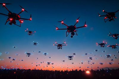
Lightweight autonomous drones provide mobility and agility to perform field tasks much more efficiently than other solutions. Their main drawback for such applications is the limited carrying capacity, imposing limits on the amount of payload they are capable of transporting, including sensory equipment and cargo. This limitation can be overcome by deploying multiple individual UAVs in parallel, such that they will cooperate on a common task.
Modern algorithms such as autonomous swarms and formation flight can allow for performing complex tasks faster and more efficiently than any individual vehicle. Additionally, cooperating UAVs also provide redundancy in case of failure of a part of the overall system, higher area coverage and flexibility, the ability to space-out sensors according to task specifications and more. Learners will be introduced to a relative localization system called Ultra-Violet Direction and Ranging (UVDAR) that uses near-ultraviolet LEDs and specialized onboard camera sensors to obtain relative localization of neighbor UAV units.
This system works independently of radio communication and is thus suitable for deployment in arbitrary conditions where such communication is unavailable. UVDAR is compatible with a wide range of light conditions, making it suitable for arbitrary outdoor and indoor deployment regardless of the time of the day. UVDAR can provide 3D relative position and orientation estimate of a neighbor UAVs with arm span of at least 40 cm, and can also provide limited data transmission capabilities.
Managing drone operations – from mission planning and data capture to compliance and analysis – is now a critical need for freelance pilots and enterprise fleets alike.
This course is suitable for all STEM professionals working in industry or students intending to make a career in industry. This course introduces operational management platform for drone fleet used in industry for various applications like logistics, retail transport, surveillance, agriculture etc.
Several platforms are introduced to the learners to understand the structure of& composition, the way It consolidates flight planning, client and asset management, airspace intelligence, team coordination, and compliance reporting in one intuitive dashboard.
This course helps drone technologists develop the ability to enrich the computer vision library and analyse the images captured by drones during surveillance. Professionals intending to develop a career in image analysis and terrain mapping.
Businesses that use warehouse drones need dedicated software solutions to efficiently manage and monitor them. A warehouse drone management system usually includes components for drone control, fleet management, data processing, and enterprise system integrations.
This course is suitable for e-commerce warehouse & logistics sector professionals. Modern warehouses deploy multiple type of drones and robots and efficient operations need a hardware agnostic platform for integrating all assets. A warehouse drone management system is a complex software platform designed to coordinate, control, and optimize drone operations within a warehouse environment. It enables fleet management, navigation, data processing, system integration, and real-time decision-making, ensuring that drones contribute efficiently to warehouse automation.
This course is suitable for professionals intending to make a career in defence, surveillance & terrain mapping through software development integrating multiple hardware on the drone.
This course further develops ability of mapping different terrain using multiple drone types. It develops the ability to plan complex missions using multiple hardware and diverse terrain covering pre-flight planning, data processing & analytics.
This course further develops the ability of professionals in terrain mapping in urban areas that require high precision. This course also introduces Hybrid drone and satellite mapping software for aerial crop analysis and precision agriculture.
This course develops the ability to convert aerial images into colourcoded maps and 2D models. Suitable for professionals of defence, civil and urban planning. This helps develop ability to convert drone images into Orthomosaics, Digital Terrain Models, Digital Surface Models, 3D Mesh
This course is suitable for Mechanical, aerospace and product design engineers intending to switch careers in drones.
Suitable for Computer science and IT professionals. This course introduces all algorithms that are used to map drone swarms and the simulation platform for predicting success in mapping coordinated flight and autonomous control.
This course is suitable for professionals who have the basic certifications in mapping and surveying and want to develop expertise in 3D model development through terrain data gathered by drones. Post certification, one will be able to fill a critical skill gap in drone mapping and be able to generate georeferenced Orthomosaics, Digital Elevation Models (DEMs), Digital Terrain Models (DTMs), point clouds, textured mesh 3D models and GIS products for a large set of market segments.
Managing drone operations – from mission planning and data capture to compliance and analysis – is now a critical need for freelance pilots and enterprise fleets alike. This course introduces comprehensive drone operations management platform purpose-built to streamline every facet of professional UAV work. It consolidates flight planning, client and asset management, airspace intelligence, team coordination, and compliance reporting in one intuitive dashboard.
This course is suitablele for engineers and product designers. With ever expanding use of drones, a product designer has ample scope for creativity to develop multi-use UAV's and control systems, integrate electronics and an integrating software.
Suitable for CS & IT professionals, coding experts and aerospace engineers. This course develops advanced skills in data analysis and planning UAV's flight to meet the desired outcomes. It's more applicable for defence applications and terrain mapping in. other sectors like civil, agriculture, urban planning etc. Learners will develop the competency to manage drone operations through the most complete flight planning solution, handle complex projects confidently - LiDAR, photogrammetry, corridor mapping, vertical scanning & more.
This course develops advanced skills in managing drone operations for last mile delivery by e-comm companies. The platform develops capabilities for managing an advanced drone management platform for last-mile logistics and commercial uses provides real-time tracking, route optimization, and automated dispatch capabilities. It integrates with existing logistics systems, allowing businesses to streamline drone delivery operations, monitor fleet performance, and manage resources efficiently.
Geospatial technology uses software to convert complex aerial images into actionable, geo-referenced insights, enabling users to analyze and understand spatial data. This is achieved through various software and tools that leverage techniques like AI, machine learning, and data processing to extract valuable information from aerial imagery, such as object detection, change analysis, and anomaly identification.This skill of converting aerial images of diverse terrain into actions through ground robots is finding huge applications in smart farming, defence, civil construction and maintenance of pipelines.
Applications which deploy a large diverse fleet of UAV's and ground robots need seamless communication network secured from jamming and counter measures. This course develops skill to design a multi-modal communications network that effectively handles a large fleet of UAV and UGV. This course is important to understand the use of electronics, radio and radar for developingng a secure communication network and further to move up the career path as an anti drone expert to develop jamming network.
Drone design is heavily influenced by the core components that enable flight and functionality. These include the airframe, propulsion system (motors, propellers, ESCs), flight controller, power system (batteries), communication systems, sensors, and payload. Each component plays a vital role, impacting the drone's performance, range, payload capacity, and overall design choices. This course develops knowledge about the various components of drone technology including the electronics,, camera, computer vision, AI algorithms and software on board which integrates the components and unifies the data for analysis.
A drone operating system for swarms needs a combination of flight control, swarm management, and data analytics capabilities. It should allow for coordinated flight, collision avoidance, and efficient resource utilization, along with a dashboard for monitoring and controlling the swarm. Designing an operating system for swarms with fully autonomous drones and analysing the data sent by each is a big challenge. This course dives deep into the design and structure of an operating system for drone swarms, integrating a dashboard for real time data analysis.
Drones offer a powerful solution for monitoring critical infrastructure and implementing predictive maintenance strategies. They enable real-time data collection, accurate assessment of conditions, and efficient maintenance planning, ultimately saving time and money. By identifying issues early and using predictive analytics, infrastructure owners can avoid costly failures and optimize their maintenance budgets.
Drones equipped with high-resolution cameras and sensors can conduct aerial surveys of infrastructure such as bridges, roads, railways, and buildings. This allows for detailed mapping and monitoring of infrastructure conditions without the need for costly helicopter or airplane surveys. This course is useful for oil pipelines maintenance, solar farm maintenance, windmill, high altitude bridges and similar installations which are hazardous for manual inspection.
This course develops skills to understand the electronics and software composition to counter drones, develop jammers or design drones that cannot be detected by radars by using fibre optics.
An anti-drone system operates by utilizing various technologies to detect, track, and mitigate unauthorized drone activities. The primary functioning of these systems involves multiple detection methods, including Radio Frequency (RF) detection, radar systems, optical sensors, and acoustic sensors.
This is the highest level of skill for a professional in drones industry, to be able to design anti-UAV techhnology and incorporate measures in surveillancee drones to counter detection or to design for detection and destroy operations of enemy drones.
Developments in anti-drone technology, such as jamming, radar, and optical systems, are driving drone design towards stealthier surveillance. This includes reducing radar cross-section, using low-frequency communication, and developing more robust camouflage techniques. These changes enhance drone survivability and effectiveness in covert surveillance missions.
Integrated counter-UAS systems are the only answer for true airspace security. By integrating various sensor technologies, the system provides operators with real-time information on drone locations and movements, helping to identify potential threats quickly. At the same time, having multiple mitigation options enables a security team to choose the most effective solution. The issue is to bring all these sensors into a single operating picture that can be quickly understood by the operator while simultaneously interrogating potential new threats.
Drones application in various industries in India is very low and the penetration is less than 5%. With diverse applications across almost all industries and services, tremendous potential exists for promoting startups in this sector.
However, being a high technology domain, promoting a startup requires a technologically savvy and diverse team with expertise in electronics (radar, chips, radio communication), AI, analytics algorithms, aerodynamics, imaging software analyst and computer vision experts. Basic frame of a drone may be same but the electronics, camera, sensors, software and other payload makes it different for adaptation across industries.
In a couple of years, an eco-system will develop with multiple startups for each sub-module.
Being the leading knowledge aggregators of Drone & Counter drone systems, we are keen to expand our intervention from training to promoting startups. Professionals and students of our University partner network getting certified in requisite skills and proving adequate competencies in entrepreneurship, can apply for gaining access to STARTUP PROJECTS across different industry sectors.
We will, after careful evaluation of the prospective team/promoter-leader, provide access to the available projects and once the founding team verifies the project details, will move forward to groom and incubate the startup with required funding, management and logistics support.
The integration of AI-driven drones in agriculture represents a transformative leap forward, offering unprecedented opportunities for efficiency, precision, and sustainability. By leveraging advanced AI algorithms and state-of-the-art drone technology, farmers can achieve significant improvements in crop monitoring, yield prediction, pest and disease management, and resource optimization. The enhanced capabilities of drones, combined with future advancements in swarm technology, autonomous navigation, and smart farming systems, promise to make agriculture more productive and environmentally friendly.
Despite the promising future, the adoption of AI and drones in agriculture comes with challenges. High initial costs, technical complexity, data privacy concerns, and regulatory hurdles are significant barriers that need to be addressed.
Manufacturing different types of drones with varying payloads and electronics is going to expand. Drones have become criticall for defence sector. Some options, in collaboration with MoD, BEL, DRDO, can be Autonomous drone swarms, surveillance drones, terrain mapping zones, object detection & movement tracking, thermal imaging for mines detection drones etc. Drone swarms are changing the battlefield. Drone swarms rely on several key technologies: artificial intelligence, encrypted communications, advanced sensors, and miniaturized components. Mastering these elements has become a strategic objective for many nations.
Defence against hostile drones is becoming complex as the protection shield needs complete situational awareness of airspace activity and protection from unwanted interference. The counter system needs to adopt complex combination of AI/ML driven multi-sensor fusion system to ingest the data from the entire spectrum of different sensors, including radar, PTZ cameras, acoustic and RF. Counter platform uses airspace security technology that fuses drone detection sensor data into a command-and-control AI-based platform with systems architecture that integrates best of class radio frequency, radar, acoustic and optical sensors for complete airspace situational awareness.
Number of startups can be composed to develop multi-layered counter drone framework, each speceialising in a technology module.
Accurate topographic maps and land surveys are the backbone of infrastructure development, land management, and construction projects. Drone photogrammetry paves the way for efficient and precise data collection, fueling more informed decision-making and successful project outcomes.
High-resolution cameras on drones capture intricate images for urban planners, enabling them to analyze and make informed decisions about land use, zoning, and infrastructure development Drones with high resolution photogrammetry payload capable of delivering orthomosaics which assist in land-use planning, infrastructure development, and disaster management, ensuring sustainable and efficient urban development.
Real Estate: Orthomosaic maps showcase large properties and provide detailed, interactive maps, enhancing property management and marketing efforts.
In mining and quarry sites, drones generate high-resolution images and precise 3D models. Such information aids planning and monitoring of extraction operations, efficiency evaluation of mining processes, and ensures environmental compliance.
This is another sector where huge possibilities for startups exist for providing services to eco firms or operating in remote areas for delivery. Companies like Amazon and UPS are testing and deploying drone fleets for last-mile delivery, promising faster shipping times and reduced operational costs.
• Route Optimization: Intelligent algorithms calculate the most efficient flight paths, avoiding congested areas and factoring in weather conditions.
• Automated Loading and Drop-off: Using machine vision—a key component of AI—drones can identify designated landing spots or mailboxes, reducing the potential for delivery errors.
One of the fastest growing commercial application of drones is for inspection & maintenance of remotely located assets. Startup are coming up for:
1. Pipeline monitoring: Monitor pipeline conditions in real-time from your control center, allowing for immediate, data-driven decisions to optimize maintenance and operations.
2. Thermal imaging: Employ thermal imaging to detect hotspots, assess insulation effectiveness, and identify potential equipment failures, preventing costly downtime.
3. Leak detection: Deploy AI-powered drones for rapid and accurate detection of leaks, enabling proactive responses to minimize environmental impact and avoid hazards.
4. Solar panel monitoring: Use drones with high-resolution cameras to inspect solar panels, detecting defects like cracks, soiling, or shading that impair efficiency.
5. Wind mill inspection; Apply AI drone technology for quick and thorough inspections of wind turbines, including blades, towers, and components.
Incorporate thermal imaging to identify internal defects not visible to the naked eye.
This is an upcoming application for many industries, converts drone images into survey-grade 2D orthomosaics and 3D point clouds with high positional accuracy, tailored to precision agriculture, bridges photogrammetry and CAD for automated industrial inspections. is particularly suited for surveying and mapping for engineering firms, precision agriculture and crop health analysis, mining and volumetric calculations, industrial inspections and digital twins. This diversity in applications creates immense possibilities for startups providing centralised services.
One of the most common uses of drone technology is to capture images and videos. This is done for surveying, mapping and inspection purposes, but it’s also popular in the real estate and entertainment industries.
Drone photographers and videographers use RPAs to capture detailed imagery. This differs from other types of drone operators, as videographers specialise in the creative side of the business. Understanding how to take beautiful photos and videos is a unique skill that extends beyond the capabilities of typical drone pilots.
As an aerial photographer and videographer, you will use commercial drones and high end cameras to create footage that can be used in movies, TV shows, advertisements, real estate marketing, weddings and more
Drone swarms are deployed to advertise products to a large audience in an effective engagement. Product launch, event promotion use drone swarms as part of media strategy.
AI drones are vital in disaster management, quickly assessing damage and locating survivors. They provide real-time data through high-resolution cameras and AI analytics, essential for rapid decision-making. Agencies receive waivers to deploy drones, ensuring swift responses in emergencies.
AI drones fill technology gaps in disaster zones, providing critical communication links when infrastructure fails. Future advancements will enhance lenses, payloads, and AI applications, expanding their use in public safety. The integration of AI technology has revolutionized aerial surveillance, expanding the capabilities of drones. These smart drone devices, equipped with advanced algorithms, now excel in real-time monitoring, threat detection, and data analysis.
AI drone technology, through the advancements in AI, is fundamentally changing the landscape of unmanned aerial operations. At the heart of this transformation are sophisticated algorithms that enable drones to perform a myriad of tasks autonomously. The use of artificial intelligence software in drones has extended their capabilities beyond mere aerial vehicles to intelligent agents capable of making decisions, adapting to environments, and executing complex missions.
GigaTwin Digital Pvt Ltd
We use cookies to analyze website traffic and optimize your website experience. By accepting our use of cookies, your data will be aggregated with all other user data.